
I-40 Closure in the Smokies: What Travelers Need to Know About the Latest Rock Slide
As someone who’s been exploring and writing about the Great Smoky Mountains for years, my heart sank when I heard the news about the latest closure of Interstate 40 through the mountain corridor. This vital east-west route has once again been severed by the powerful forces of nature that shape this beautiful but sometimes treacherous landscape.
What Happened to I-40 in the Smokies?
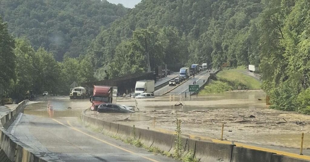
On Wednesday afternoon, heavy rainfall triggered both flooding and a significant rock slide near mile marker 450 in the narrow corridor where I-40 threads through the Great Smoky Mountains in Tennessee. This section, near Hartford, Tennessee, has been completely closed as engineers assess the damage and begin the challenging work of clearing and stabilizing the area.
If you’ve driven this stretch before, you know how the highway hugs the mountainside with the Pigeon River flowing below – it’s one of the most scenic drives in the region, but also one of the most vulnerable to the elements.
How Long Will the I-40 Closure Last?
According to preliminary assessments, engineers expect this section of I-40 to remain closed for at least two weeks. However, I’ve covered enough of these incidents over the years to know that mountain slides can be unpredictable, and timelines often extend depending on what crews discover as they work.
The combination of both flooding and rock slides creates a particularly complex situation that requires careful management to ensure the safety of both workers and future travelers.
Historical Context of Slides in the Area
This isn’t the first time this stretch of I-40 has faced such challenges. The narrow corridor through the Smokies has a long history of slides and closures. I remember covering a major closure in 2009 that lasted nearly six months and required extensive engineering work to stabilize the mountainside.
The combination of steep terrain, the region’s abundant rainfall (the Smokies receive 85+ inches annually in some areas), and the underlying geology creates perfect conditions for these events.
Recommended Detours Around the I-40 Closure
For travelers planning to cross the Smokies in the coming weeks, you’ll need to adjust your route. Based on my experience with previous closures, here are your best options:
- I-26 to I-81: The official detour takes travelers north from Asheville on I-26 to Johnson City, then west on I-81 to reconnect with I-40 near Knoxville. This adds about 45 minutes to the trip under normal conditions.
- US-441 through the National Park: If you’re in no hurry and want to enjoy the scenery, consider taking Newfound Gap Road through the heart of the Great Smoky Mountains National Park. Just be aware this is a two-lane mountain road with slower speeds.
- US-25/70: Local travelers familiar with the area might consider this alternate route, though it’s not recommended for large vehicles or those unfamiliar with mountain driving.
Impact on Local Communities
These closures affect more than just through travelers. The communities along this corridor, including Hartford, Cosby, and Newport, often feel economic impacts when the interstate closes. Local businesses that rely on interstate traffic see sharp declines, while detour routes can become congested with diverted traffic.
Having covered several previous closures, I’ve seen how these events ripple through the local economy, affecting everything from gas stations to lodging establishments.
What Makes This Section of I-40 So Vulnerable?
I’ve always been fascinated by the engineering challenges of this highway corridor. When I-40 was constructed through the Smokies in the 1960s, engineers faced the monumental task of carving a path through some of the most rugged terrain in the eastern United States.
The combination of steep mountain slopes, the narrow river gorge, and the region’s high rainfall creates ongoing challenges for maintaining this vital transportation link. In many spots, the mountain was literally cut away to make room for the highway, creating tall, exposed rock faces that remain vulnerable to weathering and slides.
Staying Updated on the Closure
If you’re planning travel through this area in the coming weeks, I recommend:
- Checking the Tennessee Department of Transportation (TDOT) website regularly
- Using the TDOT SmartWay app for real-time updates
- Following local news sources from both Tennessee and North Carolina for the latest information
- Building extra time into your travel plans if you need to cross the mountains
Having reported on similar closures, I can tell you that these situations evolve daily, with timelines often shifting based on conditions and what crews discover during the cleanup and stabilization process.
Final Thoughts
As someone who loves these mountains, I’m always reminded of their power and unpredictability when events like this occur. While the closure creates challenges for travelers and local communities, it also highlights the ongoing dance between human infrastructure and natural forces in this beautiful region.
If your travel plans take you near the Smokies in the coming weeks, pack some extra patience along with your sense of adventure. And perhaps take the opportunity to explore some of the less-traveled routes through one of America’s most beloved mountain ranges – sometimes detours lead to unexpected discoveries.
Source: Associated Press