
Interstate 40 Closure: Rock Slide and Flooding in the Smokies Impact Major Cross-Country Highway
The Great Smoky Mountains are showing their wild side again. As someone who’s been trekking these peaks and writing about their temperamental nature for years, I’ve seen firsthand how Mother Nature can transform this breathtaking landscape in an instant. The recent closure of Interstate 40 through the Smokies corridor is a stark reminder of the region’s unpredictable geological character.
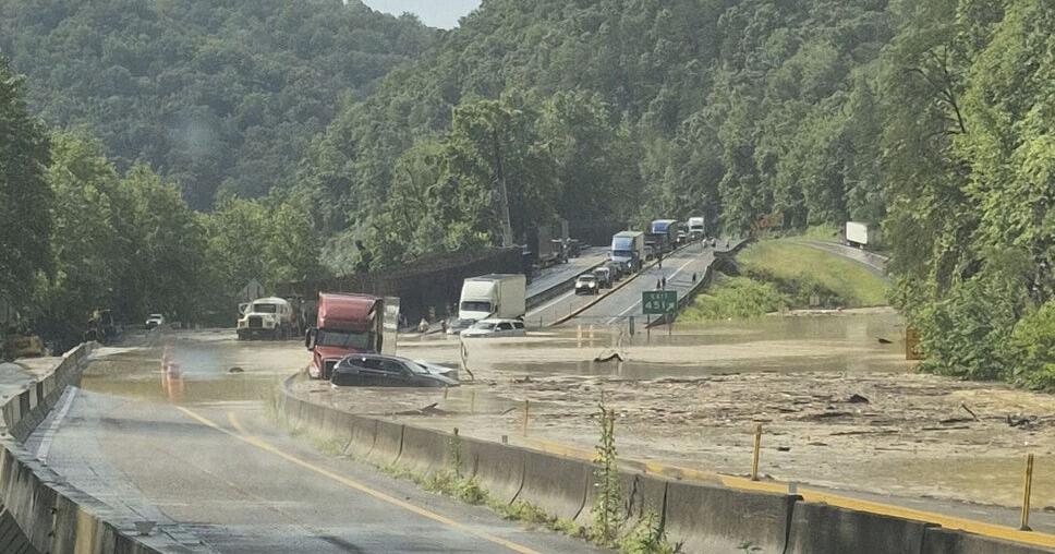
Emergency Closure Along the Tennessee Border
Heavy rainfall this Wednesday caused significant flooding and triggered a rock slide near mile marker 450 in Hartford, Tennessee. This section of I-40, which serves as a critical cross-country artery through the narrow mountain corridor, is now completely shut down. According to engineers on site, the highway will remain closed for at least two weeks as crews work to clear debris and assess structural damage.
This closure isn’t just an inconvenience—it’s a major disruption to one of America’s most vital east-west transportation routes. Each day, thousands of travelers and commercial vehicles rely on this stretch of interstate that winds through some of the most challenging terrain in the eastern United States.

Not the First Time: The Smoky Mountains’ History with Slides
If you’ve spent any time in these mountains, you know this isn’t an isolated incident. The narrow passage of I-40 through the Smokies has a long history of closures due to rock slides and flooding. The combination of steep slopes, fractured bedrock, and the region’s significant rainfall makes this corridor particularly vulnerable.
I remember back in 2009 when a massive rock slide near the North Carolina-Tennessee border closed I-40 for several months. Local businesses felt the economic impact for years afterward. These mountains may look solid, but they’re constantly shifting and changing—especially during periods of heavy precipitation.
What This Means for Travelers
If you’re planning a trip through this region in the next few weeks, you’ll need to prepare for significant detours. The official alternate route directs traffic to I-81 through Kingsport, TN, adding approximately 45 minutes to most journeys. However, locals (myself included) know that smaller highways like US-25/70 can provide scenic alternatives if you’re not in a hurry and don’t mind mountain driving.
For truckers and commercial drivers, this closure presents more serious logistical challenges. The narrow, winding nature of alternative routes makes them less suitable for large vehicles, potentially causing ripple effects throughout the supply chain.
| Route | Added Time | Best For |
|---|---|---|
| I-81 to I-26 | ~45 minutes | All vehicles, official detour |
| US-25/70 | ~30 minutes | Local traffic, smaller vehicles |
| US-321 to US-441 | ~1 hour | Scenic route, tourist traffic |
The Environmental Perspective
While road closures frustrate travelers, they also highlight the delicate balance between human infrastructure and natural processes in the Smokies. These mountains were here long before our highways, and events like this remind us of nature’s ultimate authority.
The increased frequency of extreme weather events has contributed to more rock slides and flooding in recent years. As someone who’s watched these mountains change over time, I’ve noticed how heavier rainfall patterns are reshaping trails, roads, and waterways throughout the region.
Community Impact and Response
Local communities in Hartford and nearby towns are already mobilizing to assist stranded travelers and prepare for potential economic impacts. If you’re a resident or business owner in the affected area, county emergency management offices are coordinating resources and information.
Having seen how previous closures affected the region, I can tell you that the resilience of mountain communities is remarkable. Local businesses often find creative ways to welcome diverted travelers, turning an inconvenience into an opportunity to showcase the region’s hospitality.
Looking Ahead: The Reopening Process
Tennessee Department of Transportation crews are already on site assessing damage and beginning the cleanup process. The two-week timeline represents their initial estimate, but mountain repair projects are notoriously unpredictable. Weather conditions, additional geological movement, and the extent of infrastructure damage will all factor into the actual reopening date.
I’ll be following this situation closely, as I’ve done with previous closures in this magnificent but challenging landscape. The Smokies may temporarily close our roads, but they never fail to remind us why we’re drawn to their rugged beauty in the first place.
For the latest updates on the I-40 closure, travelers should consult the Tennessee Department of Transportation’s SmartWay map or call 511 before beginning their journey.